Helium Project of Kim, Colorado.
Objective
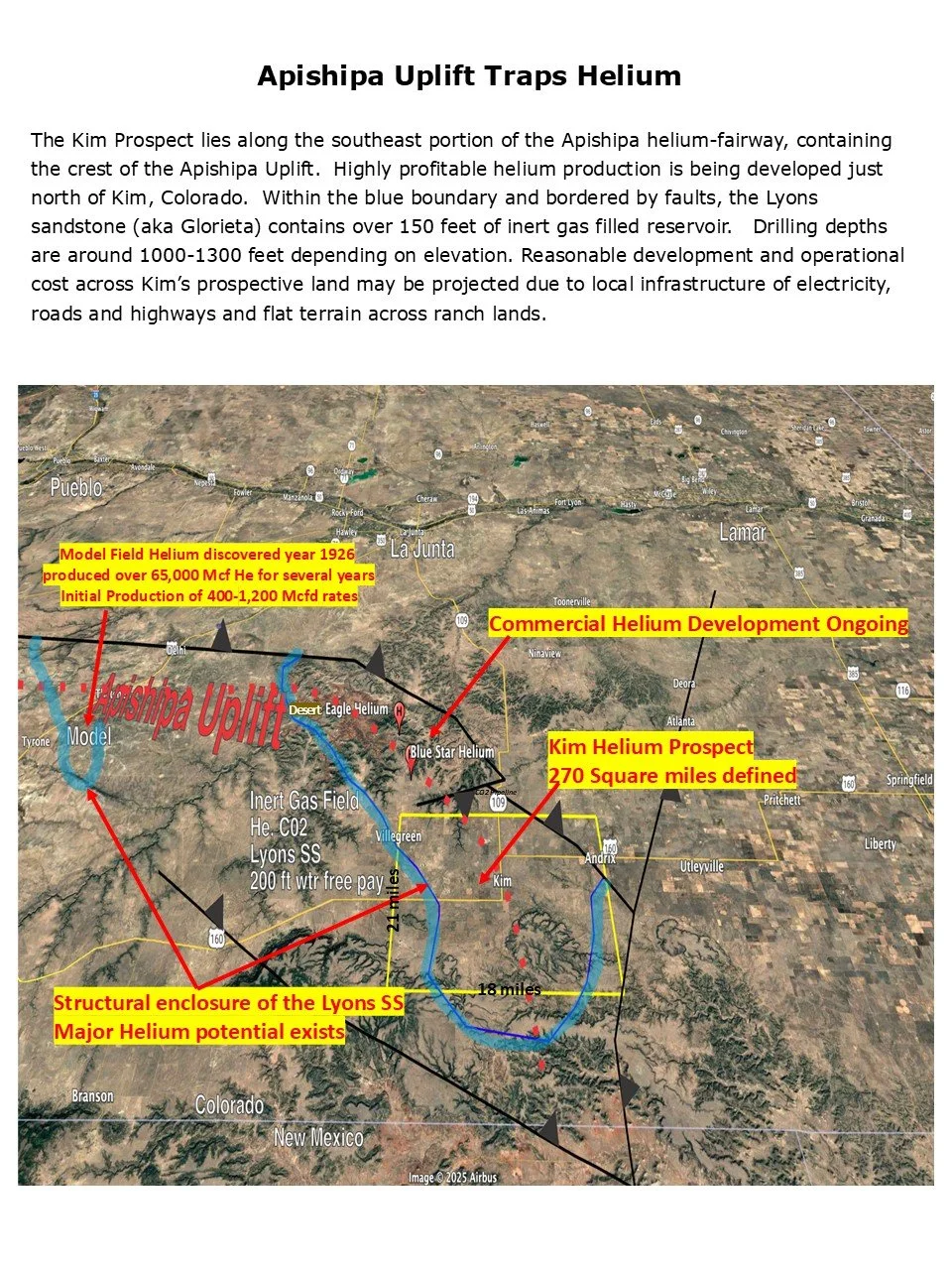
We anticipate extending commercial concentrations of Helium within the shallow proven Lyons sand of Permian age. Sufficient well control and nearby production indicates the project may contain a range of 15,000 to 50,000 Mcf of helium per well. A gross helium production value is estimated to be 5 to 15 million dollars per well using a market price of $350 per Mcf, The prospect contains enough acreage to drill over 70 helium wells at average depths of 1,350 feet. Leases cover 21,214 gross and 11,639 net acres centered around the town of Kim, Colorado of Las Animas County.
Target Zone Lyons Formation
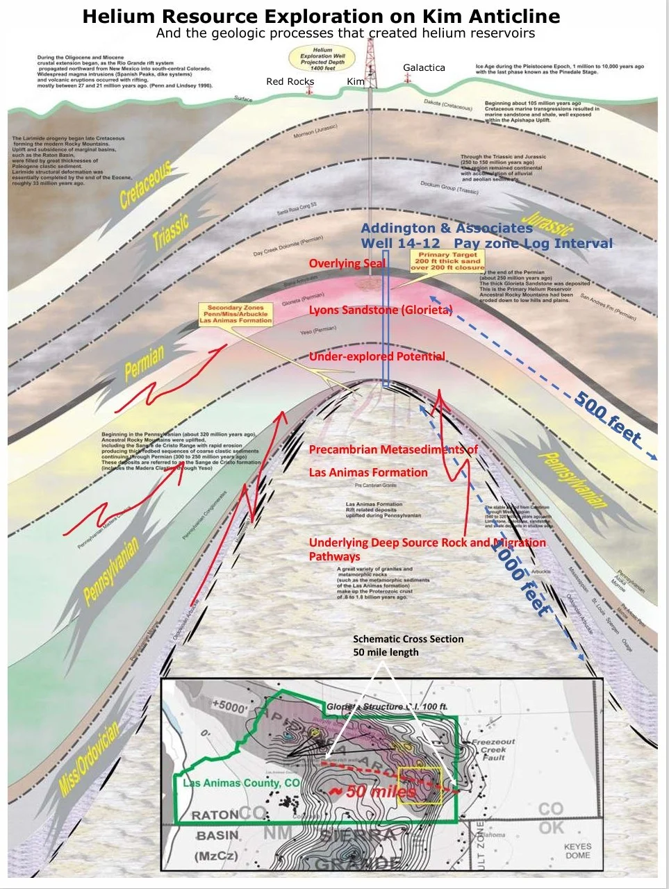
The Lyons sand (also referred herein as the Glorieta from New Mexico nomenclature) is classified as a quartzose sandstone deposited in a dune setting with minor fluvial influences. Porosities range from 22-30 percent with reportedly excellent permeabilities. Centered within the Kim prospect is a well in Section 14 of T32S-R53W drilled into basement granite to a depth of 1,966 feet. Open hole geophysical logs indicate 137 net feet of highly porous gas filled Lyons sand at a depth of 1,272 feet. Helium wells in the area produce water free, demonstrating the impact of the structural trapping mechanism. Wells will be completed open hole by cementing casing to surface just above the Lyons, then drilling and naturally producing the reservoir’s gas
Apishipa Uplift
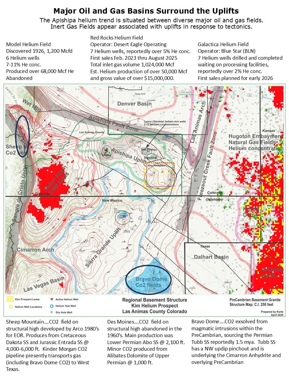
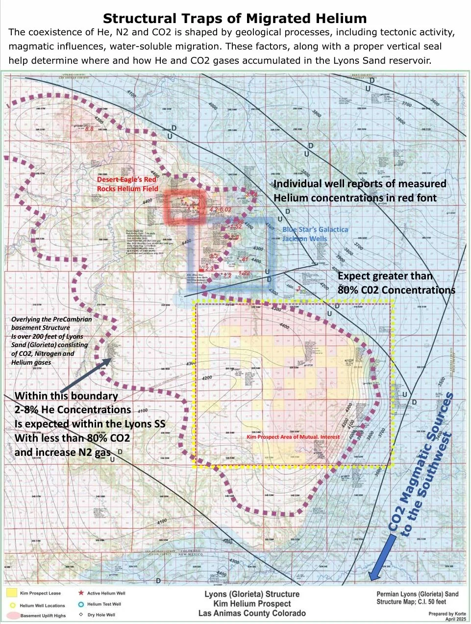
Kim prospect area is strategically located on the crest of the Apishipa Uplift, considered a premier pure helium play gaining increased activity. With over 500 feet of structural relief, the Lyons as well as deeper sediments form gas traps. Underlying the Lyons sand are Permian-Pennsylvanian to Pre-Cambrian cherts of the Las Animas metasediments. These multiple reservoirs overly basement granite found at drilling depths of around 2,000 feet. These older rocks are considered the primary source for the helium gas trapped in reservoirs having overlying seals.
Offset Production
To the north of Kim and along the Apishipa Uplift, exploration, development and production of helium wells have been ongoing for the past several years. The Red Rocks field, located 10 miles north of Kim leases, consists of eight open hole producing wells within the Lyons sand. The field is operated by Desert Eagle Operating of Dallas, Texas. Since February of 2023, the field has reported production of 1,024,000 Mcf inlet gas. During the month of Aug 2025 production was 50,395 Mcf. Helium concentrations reportedly exceed 5%. Blue Star Helium Ltd (Blue Star) in joint venture with Helium One Global Ltd are preparing their Pinion Canyon Plant for commercial helium production. This plant is located 5 miles north of Kim leases and awaits construction and gathering for 7 recently completed helium wells.
Mapping
Uplifted helium source rocks and reservoir accumulations of associated inert gas defines the helium-fairway of the Apishipa Uplift. The geologic setting is shaped from available well information from across the region. Data includes geophysical open hole logs, old well sample descriptions and various geological surveys. Regional structural and resource maps along with geologic cross sections support Kim’s potential. The Kim prospect maps include 49 townships and details historical helium production, well tests, recent discoveries and their relationship to the Kim prospect Area of Mutual Interest (AMI). Lease ownerships are described across the sections of land where leases are held.
Summary
This “greenfield” exploration project has proven reservoirs located on structure, capable of producing highly profitable helium gas. Comparable to helium production to the north, the prospect is set up to drill and test the Permian Lyons sand for its flow potential and gas composition. Depending on results, development of the field would proceed with additional wells gathered to a central site where third party processing and marketing of gas occurs. Well situated along infrastructure, a multi well field development offers low drilling costs and benefits of scale for long term production. Acreage is being offered at $100 per net acre with an 80% Net Revenue Interest (NRI).
Please direct questions regarding this prospect to the following:
Mike Korte (PARTNER): kortemike@ymail.com (918)214-7764
Kevin Konrade (PARTNER): konradek@sbcglobal.net (405)203-4894